Static Map Catalogue - Full Metadata Record
Collection SkySat
SkySat ESA Archive. More details.
SSC_OPER_SSC_DEF_CO_20210614T130821_S13-477_W047-312_01
Download Product | Browse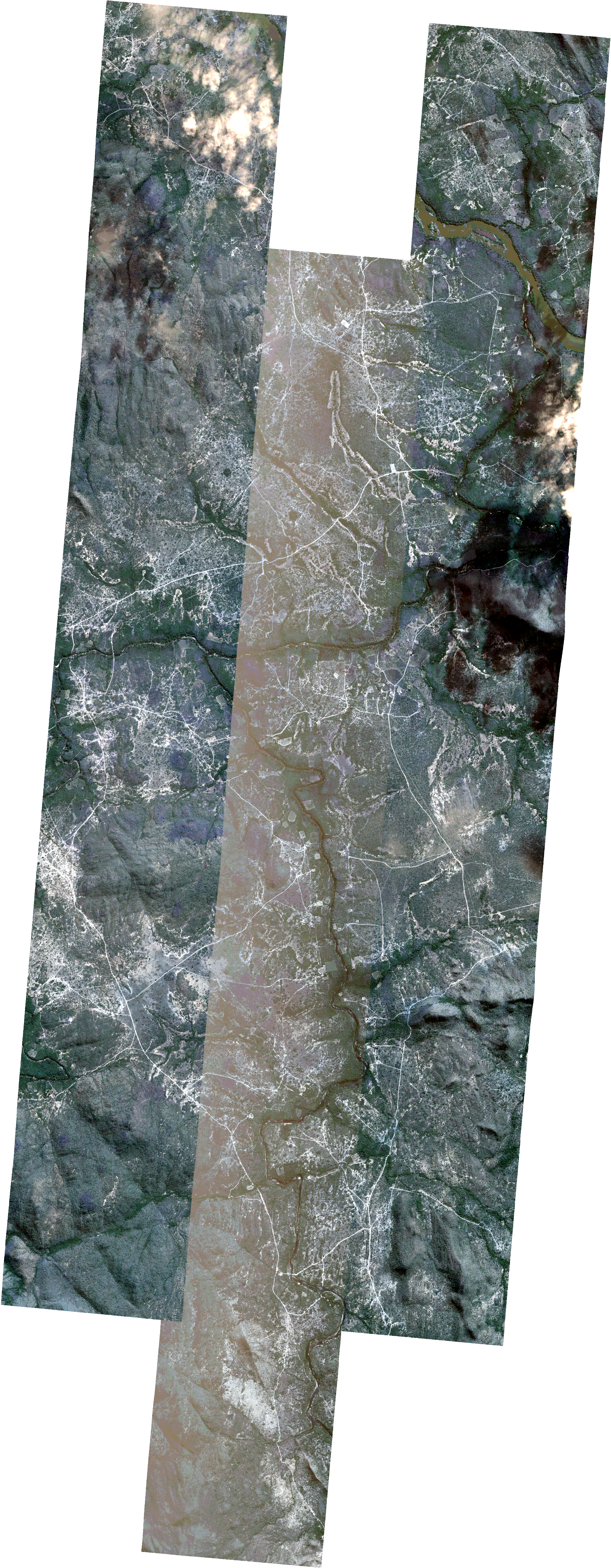
Path | W047 |
Row | S13 |
Start Date | 2021-06-14T13:08:21Z |
Stop Date | 2021-06-14T13:08:21Z |
Availability Time | 2021-06-14T13:08:21Z |
Platform Short Name | SkySat |
Instrument Short Name | SkySat Camera |
Sensor Type | OPTICAL |
Operational mode | CAMERA |
Resolution | 0.5 |
Orbit Number | 0 |
Orbit Direction | |
Illumination Azimuth Angle | 39.1 |
Illumination Elevation Angle | 42.8 |
Across Track Incidence Angle | 5.4 |
Footprint | -13.5530709334 -47.3108356213 -13.5460981761 -47.3101371642 -13.5460949826 -47.310170045 -13.5391442996 -47.3094502712 -13.5391397067 -47.3094976955 -13.5358974918 -47.3091838968 -13.5376623889 -47.2914524374 -13.5294546317 -47.2906597014 -13.5294535974 -47.2906701096 -13.5224761018 -47.2899748144 -13.5224733425 -47.2900026858 -13.5155142007 -47.2893040957 -13.5155101836 -47.2893447831 -13.5085655437 -47.2886271634 -13.5085633892 -47.2886490723 -13.5016281689 -47.287871962 -13.5016188775 -47.2879665804 -13.4946476893 -47.2873235403 -13.4946463676 -47.287337119 -13.4876914641 -47.2866605212 -13.4876875523 -47.2867008637 -13.4807369164 -47.2860220201 -13.4807335147 -47.2860572359 -13.4737872219 -47.2853625692 -13.4737843457 -47.2853924798 -13.4668391338 -47.2846809916 -13.466835479 -47.2847192256 -13.4611343423 -47.284033125 -13.4611379191 -47.2839946124 -13.4603787418 -47.2839421926 -13.4598886315 -47.2838832105 -13.4598862748 -47.2839081887 -13.452950148 -47.2834292621 -13.4529451963 -47.2834812944 -13.4460056115 -47.2827531254 -13.4459986438 -47.2828268969 -13.4390732805 -47.2821660846 -13.4390678063 -47.2822237309 -13.4321382451 -47.2815348339 -13.4321322098 -47.2815985929 -13.4252049808 -47.280899744 -13.4251991232 -47.2809620133 -13.4182680798 -47.2802605199 -13.4182626135 -47.2803192307 -13.4113127729 -47.2796044127 -13.4113073139 -47.279663595 -13.4043508388 -47.2789605743 -13.4043494313 -47.2789759098 -13.3973883253 -47.2783168753 -13.3955526276 -47.2983286764 -13.4037818385 -47.2991756442 -13.4037871046 -47.2991172394 -13.4107349461 -47.2998247125 -13.4107409393 -47.2997594337 -13.4176869041 -47.3004660166 -13.4176940594 -47.3003887404 -13.4210196466 -47.3007144416 -13.4196197406 -47.3160019208 -13.4155010087 -47.3155886371 -13.4154923509 -47.3156790894 -13.4085690733 -47.3149909949 -13.4085620899 -47.3150649016 -13.4016200283 -47.3143671005 -13.4016131763 -47.3144400679 -13.3946746882 -47.3137400984 -13.392791652 -47.3337017949 -13.4010268668 -47.334579703 -13.4010356137 -47.3344860297 -13.407955608 -47.3351684673 -13.4079622768 -47.3350978563 -13.4148901943 -47.335773268 -13.4149020685 -47.3356485214 -13.4217984895 -47.336333559 -13.4218082872 -47.3362318692 -13.4286799919 -47.3368182556 -13.4286865612 -47.3367514703 -13.4356073127 -47.3374887898 -13.4356165668 -47.3373944309 -13.44254438 -47.3382145582 -13.4425535573 -47.3381198316 -13.4494770663 -47.3389122511 -13.4494866345 -47.3388131567 -13.4563981738 -47.3395553634 -13.4564069128 -47.3394649527 -13.4633219986 -47.3402048456 -13.4633294072 -47.3401284548 -13.4702471284 -47.3408455166 -13.4702533584 -47.3407814665 -13.4771769808 -47.3414942224 -13.4771835605 -47.3414268026 -13.4841035499 -47.3421487406 -13.4841100774 -47.3420819383 -13.4910359558 -47.3427940552 -13.4910413044 -47.3427397733 -13.4979739067 -47.3434544682 -13.4979794629 -47.3433981993 -13.5049101657 -47.3441227189 -13.5049162607 -47.3440613454 -13.5118454075 -47.3447514253 -13.511850947 -47.3446958233 -13.5187899856 -47.3453416321 -13.5187967536 -47.3452738343 -13.5257222958 -47.3460667987 -13.525728834 -47.3460018095 -13.5327156801 -47.3466423938 -13.5344792952 -47.3290971799 -13.5384711752 -47.3294846644 -13.5384748584 -47.3294466389 -13.5454106943 -47.3301930264 -13.5454135558 -47.3301634859 -13.5523638927 -47.3308575187 -13.5523658151 -47.330837729 -13.5593524739 -47.331451842 -13.5612717192 -47.3116378055 -13.5530728255 -47.3108161995 -13.5530709334 -47.3108356213 |
Scene Centre | -13.4770339939 -47.3124796346 |
Size | 8590936390 |
Product type | SSC_DEF_CO |
Acquisition Type | NOMINAL |
Cloud-Cover Percentage | 0.01 |
Original Name | 20210614_130821_ssc13_u0001_SkySatCollect |
Bounding Box | -13.392791652 -47.3466423938 -13.5612717192 -47.3466423938 -13.5612717192 -47.2783168753 -13.392791652 -47.2783168753 |