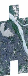
Static Map Catalogue - Full Metadata Record
Collection SkySat
SkySat ESA Archive. More details.
SSC_OPER_SSC_DEF_CO_20211012T062216_N21-040_E105-842_01
Download Product | BrowsePath | E105 |
Row | N21 |
Start Date | 2021-10-12T06:22:16Z |
Stop Date | 2021-10-12T06:22:16Z |
Availability Time | 2021-10-12T06:22:16Z |
Platform Short Name | SkySat |
Instrument Short Name | SkySat Camera |
Sensor Type | OPTICAL |
Operational mode | CAMERA |
Resolution | 0.5 |
Orbit Number | 0 |
Orbit Direction | |
Illumination Azimuth Angle | 223.1 |
Illumination Elevation Angle | 52.5 |
Across Track Incidence Angle | 26.9 |
Footprint | 20.9712112178 105.832853538 20.9712284141 105.833013576 20.9794622348 105.833039106 20.9794702773 105.833113009 20.9876613713 105.833136662 20.9876643396 105.833163712 20.9922634562 105.833178543 20.994096039 105.85064762 20.9912072248 105.850638442 20.9912010329 105.850579924 20.9829344821 105.850564524 20.9829236901 105.850461404 20.9745699076 105.850436932 20.9745498465 105.850242643 20.9650559677 105.85022302 20.9674468996 105.872916483 20.9757720959 105.872904104 20.9757970156 105.873141044 20.9840883678 105.873148756 20.9841050463 105.873305116 20.9923327819 105.873299264 20.9923444646 105.873407695 21.0006052631 105.87341929 21.0006164109 105.873521273 21.0088450044 105.873503064 21.0088572846 105.873614816 21.0171082428 105.873615959 21.0171205908 105.873728232 21.0253913149 105.873738053 21.0254039412 105.87385074 21.0336515192 105.873856179 21.0336618986 105.87394799 21.0419192615 105.873957734 21.04192912 105.874043906 21.0501351469 105.87403759 21.0501426094 105.874101432 21.0583760891 105.874123843 21.0583822897 105.874176183 21.0665927468 105.874178776 21.0666076263 105.874303289 21.074833547 105.874256095 21.0748425379 105.874331346 21.0830826056 105.8742985 21.0830916198 105.874371943 21.0928916086 105.874330248 21.0904006469 105.853853923 21.0939703065 105.853844023 21.0939909779 105.854017781 21.1022531331 105.854021014 21.1022551614 105.854038137 21.1105229797 105.854041791 21.1105249176 105.85405799 21.1203187103 105.854087778 21.117522091 105.830838891 21.1077432425 105.8308065 21.1077483191 105.830848934 21.0995055106 105.830826556 21.0995103714 105.830867589 21.0927039453 105.830827918 21.0927018369 105.830810078 21.0872153267 105.830794458 21.0846193513 105.810050134 21.0747664072 105.810000477 21.0747780059 105.810092333 21.066664307 105.810054658 21.0666730882 105.810125482 21.0585034134 105.810069532 21.0585140136 105.810154853 21.0504401494 105.810139183 21.0504511097 105.810231578 21.0423138649 105.810206655 21.0423233766 105.810287771 21.0341693409 105.810257433 21.0341761253 105.810315396 21.0259877624 105.810271213 21.025993885 105.810323571 21.0178422793 105.810297199 21.0178458992 105.810329072 21.0096546677 105.810282736 21.0096579041 105.81031141 21.0014900839 105.810276619 21.0014934301 105.810306476 20.9933134097 105.810262128 20.9933178877 105.810302587 20.9851503969 105.81025438 20.9851525798 105.810274274 20.978301649 105.810237414 20.9782988381 105.810211245 20.9700134854 105.810172115 20.9700025125 105.81006815 20.9604747269 105.810009483 20.9628920857 105.832822445 20.9712112178 105.832853538 |
Scene Centre | 21.0403997478 105.84218621 |
Size | 12384420561 |
Product type | SSC_DEF_CO |
Acquisition Type | NOMINAL |
Cloud-Cover Percentage | 0.03 |
Original Name | 20211012_062216_ssc10_u0001_SkySatCollect |
Bounding Box | 21.1203187103 105.810000477 20.9604747269 105.810000477 20.9604747269 105.874371943 21.1203187103 105.874371943 |
