Static Map Catalogue - Full Metadata Record
Collection SkySat
SkySat ESA Archive. More details.
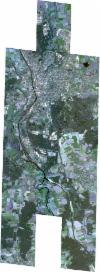
SSC_OPER_SSC_DEF_CO_20200411T104657_N52-486_E007-329_01
Download Product | BrowsePath | E007 |
Row | N52 |
Start Date | 2020-04-11T10:46:57Z |
Stop Date | 2020-04-11T10:46:57Z |
Availability Time | 2020-04-11T10:46:57Z |
Platform Short Name | SkySat |
Instrument Short Name | SkySat Camera |
Sensor Type | OPTICAL |
Operational mode | CAMERA |
Resolution | 0.5 |
Orbit Number | 0 |
Orbit Direction | |
Illumination Azimuth Angle | 164.3 |
Illumination Elevation Angle | 45.2 |
Across Track Incidence Angle | 27.8 |
Footprint | 52.4094641465 7.38028898689 52.418479395 7.38055671779 52.4184942705 7.38029061615 52.4275575287 7.38055680846 52.4275731455 7.38027558069 52.4365742201 7.38054717431 52.4365923189 7.38023478026 52.445690129 7.38047831488 52.4457092363 7.38013305144 52.4552788423 7.38041727083 52.4552966139 7.38010003909 52.4649323484 7.38038938589 52.4649500091 7.38006284934 52.4745100129 7.38036241315 52.4745252671 7.38008936809 52.483463538 7.38041507573 52.4834722454 7.38026292897 52.4925366311 7.38049239705 52.4925526956 7.38020658676 52.5015393261 7.3804613651 52.5015588348 7.38012146187 52.5106412278 7.38033009475 52.5106591843 7.38002028028 52.5197416363 7.38026030229 52.5197571096 7.37999232506 52.5287933199 7.38022295864 52.528812257 7.37989335007 52.5378288418 7.38013722862 52.5396209299 7.34868468924 52.5447988872 7.34880747615 52.5448116825 7.34858050091 52.5538358983 7.34876374875 52.5538480006 7.34855110768 52.5627646097 7.34876398319 52.5627779697 7.34853034864 52.5717202107 7.34875582229 52.573864756 7.31206508526 52.5631935184 7.3118404176 52.5631819976 7.3120400083 52.5541771002 7.31185413637 52.5541677454 7.3120182387 52.5451546841 7.31186006976 52.5451440337 7.31204937739 52.5407134541 7.31193239189 52.5426683339 7.27974139876 52.5320320498 7.27954261051 52.5320208735 7.27973369559 52.5229976029 7.27952579102 52.522986724 7.27971043104 52.5139225209 7.27951583748 52.513912974 7.27967918181 52.5048465503 7.2794794293 52.5048380231 7.27962547371 52.4957804936 7.27941539244 52.4957713107 7.27957188803 52.486719989 7.27935355804 52.4867112728 7.27949814934 52.4776088212 7.27931055295 52.477602341 7.2794234666 52.4685417975 7.27923422148 52.4685331887 7.27938677112 52.4588639147 7.27919025099 52.4588547714 7.27935043949 52.4491997219 7.2791473681 52.4491927386 7.2792702875 52.4395536888 7.27908345252 52.4395437953 7.2792532437 52.4304622531 7.27909895413 52.4304555613 7.27921795205 52.4213628347 7.27905716224 52.421355858 7.27918159335 52.4122596811 7.27899347133 52.4122528502 7.27911590698 52.4031571797 7.27892720181 52.4010868957 7.31605670238 52.4120216808 7.31627955706 52.4120316621 7.31610008235 52.4210469857 7.31630541476 52.4210579787 7.31611138821 52.430180219 7.31630270753 52.4301912744 7.31610725419 52.4351275402 7.3162196793 52.4335809914 7.34349521969 52.427821704 7.34334986087 52.4278102593 7.34355751406 52.4187426188 7.34331236858 52.4187319092 7.34350360872 52.409681237 7.34325575322 52.4096700792 7.34345487016 52.400616477 7.34320382053 52.3985369949 7.38025394945 52.409449467 7.38055189933 52.4094641465 7.38028898689 |
Scene Centre | 52.4862117597 7.32974200514 |
Size | 12503944153 |
Product type | SSC_DEF_CO |
Acquisition Type | NOMINAL |
Cloud-Cover Percentage | 0 |
Original Name | 20200411_104657_ssc1_u0002_SkySatCollect |
Bounding Box | 52.573864756 7.27892720181 52.3985369949 7.27892720181 52.3985369949 7.38055680846 52.573864756 7.38055680846 |
