Static Map Catalogue - Full Metadata Record
Collection GEOSAT
GEOSAT ESA archive. More details here.
DE2_OPER_HRA_PSH_1C_20200403T083704_N47-857_E028-009_0000
Download Product | Browse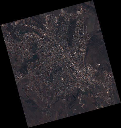
Start Date | 2020-04-03T08:37:04Z |
Stop Date | 2020-04-03T08:37:07Z |
Availability Time | 2020-04-03T08:37:07Z |
Instrument Short Name | HiRAIS |
Sensor Type | OPTICAL |
Operational mode | PSH |
Resolution | 0.75 |
Orbit | 31375 |
Satellite | GEOSAT-2 |
Product type | HRA_PSH_1C |
Orbit Direction | ASCENDING |
Scene Centre Longitude | E028 |
Scene Centre Latitude | N47 |
Illumination Azimuth Angle | 147.669712076 |
Illumination Elevation Angle | 44.1732 |
Footprint | 47.056985 28.754328 47.083947 28.916093 46.961038 28.960128 46.934076 28.798363 47.056985 28.754328 |
Product Size | 2131534952 |
Cloud Cover Percentage | 0 |
Acquisition Type | NOMINAL |
Bounding Box | 47.083947 28.754328 46.934076 28.754328 46.934076 28.960128 47.083947 28.960128 |
Original name | DE2_PSH_L1C_000000_20200403T083704_20200403T083707_DE2_31375_6110 |