Static Map Catalogue - Full Metadata Record
Collection GEOSAT
GEOSAT ESA archive. More details here.
DE2_OPER_HRA_PSH_1C_20200316T084328_N45-004_E028-456_0000
Download Product | Browse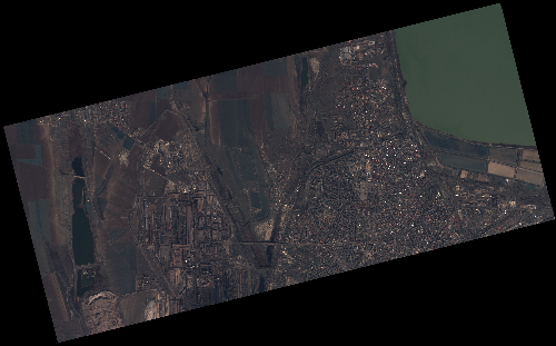
Start Date | 2020-03-16T08:43:28Z |
Stop Date | 2020-03-16T08:43:29Z |
Availability Time | 2020-03-16T08:43:29Z |
Instrument Short Name | HiRAIS |
Sensor Type | OPTICAL |
Operational mode | PSH |
Resolution | 1.0 |
Orbit | 31108 |
Satellite | GEOSAT-2 |
Product type | HRA_PSH_1C |
Orbit Direction | ASCENDING |
Scene Centre Longitude | E028 |
Scene Centre Latitude | N45 |
Illumination Azimuth Angle | 149.607136524 |
Illumination Elevation Angle | 38.7144 |
Footprint | 45.467544 27.917564 45.493792 28.075556 45.445274 28.092030 45.419026 27.934038 45.467544 27.917564 |
Product Size | 462159570 |
Cloud Cover Percentage | 0 |
Acquisition Type | NOMINAL |
Bounding Box | 45.493792 27.917564 45.419026 27.917564 45.419026 28.09203 45.493792 28.09203 |
Original name | DE2_PSH_L1C_000000_20200316T084328_20200316T084329_DE2_31108_9AFE |