ESA TPM Map Catalogue - Product List
back to previous node |
list of download URLs
Collection G2_Portugal_2021
GEOSAT-2 Portugal Coverage 2021 collection. More details here.
List of available products (latitude from 41.6044 to 41.6793 dg, longitude from -8.255 to -8.11063 dg)..
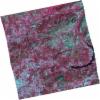
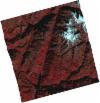
DE2_OPER_HRA_PSH_1C_20210406T111256_N41-679_W008-274_0001
Download Product | Product Info | Browse
Platform Short Name | GEOSAT |
Platform Serial Identifier | 2 |
Product Type | HRA_PSH_1C |
Start Date | 2021-04-06T11:12:56Z |
Stop Date | 2021-04-06T11:12:58Z |
Original Name | DE2_PSH_L1C_000000_20210406T111256_20210406T111258_DE2_36837_BAC7.zip |
Footprint | 41.6251938809 -8.16932845652 41.7586868775 -8.20589822618 41.7337022765 -8.37981141787 41.6003565395 -8.34179636108 41.6251938809 -8.16932845652 |
Orbit Direction | ASCENDING |
Scene Centre Longitude | W008 |
Scene Centre Latitude | N41 |
Cloud Cover Percentage | -1 |
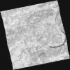
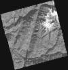
DE2_OPER_HRA_PM4_1C_20210406T111256_N41-679_W008-274_0001
Download Product | Product Info | Browse
Platform Short Name | GEOSAT |
Platform Serial Identifier | 2 |
Product Type | HRA_PM4_1C |
Start Date | 2021-04-06T11:12:56Z |
Stop Date | 2021-04-06T11:12:58Z |
Original Name | DE2_PM4_L1C_000000_20210406T111256_20210406T111258_DE2_36837_BAC7.zip |
Footprint | 41.6251938809 -8.16932845652 41.7586868775 -8.20589822618 41.7337022765 -8.37981141787 41.6003565395 -8.34179636108 41.6251938809 -8.16932845652 |
Orbit Direction | ASCENDING |
Scene Centre Longitude | W008 |
Scene Centre Latitude | N41 |
Cloud Cover Percentage | -1 |
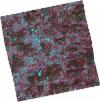
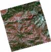
DE2_OPER_HRA_PSH_1C_20210406T111254_N41-558_W008-241_0001
Download Product | Product Info | Browse
Platform Short Name | GEOSAT |
Platform Serial Identifier | 2 |
Product Type | HRA_PSH_1C |
Start Date | 2021-04-06T11:12:54Z |
Stop Date | 2021-04-06T11:12:56Z |
Original Name | DE2_PSH_L1C_000000_20210406T111254_20210406T111256_DE2_36837_0E3F.zip |
Footprint | 41.5037560361 -8.13781232538 41.637573341 -8.17264544098 41.612834929 -8.34436100248 41.4790330095 -8.30924908814 41.5037560361 -8.13781232538 |
Orbit Direction | ASCENDING |
Scene Centre Longitude | W008 |
Scene Centre Latitude | N41 |
Cloud Cover Percentage | -1 |
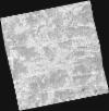
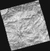
DE2_OPER_HRA_PM4_1C_20210406T111254_N41-558_W008-241_0001
Download Product | Product Info | Browse
Platform Short Name | GEOSAT |
Platform Serial Identifier | 2 |
Product Type | HRA_PM4_1C |
Start Date | 2021-04-06T11:12:54Z |
Stop Date | 2021-04-06T11:12:56Z |
Original Name | DE2_PM4_L1C_000000_20210406T111254_20210406T111256_DE2_36837_0E3F.zip |
Footprint | 41.5037560361 -8.13781232538 41.637573341 -8.17264544098 41.612834929 -8.34436100248 41.4790330095 -8.30924908814 41.5037560361 -8.13781232538 |
Orbit Direction | ASCENDING |
Scene Centre Longitude | W008 |
Scene Centre Latitude | N41 |
Cloud Cover Percentage | -1 |
DE2_OPER_HRA_PSH_1C_20210108T105348_N41-735_W008-152_0001
Download Product | Product Info | Browse
Platform Short Name | GEOSAT |
Platform Serial Identifier | 2 |
Product Type | HRA_PSH_1C |
Start Date | 2021-01-08T10:53:48Z |
Stop Date | 2021-01-08T10:53:51Z |
Original Name | DE2_PSH_L1C_000000_20210108T105348_20210108T105351_DE2_35531_6B08.zip |
Footprint | 41.687204411 -8.05029491056 41.8152723312 -8.09245275442 41.7838578875 -8.25549856635 41.6558853059 -8.21279205745 41.687204411 -8.05029491056 |
Orbit Direction | ASCENDING |
Scene Centre Longitude | W008 |
Scene Centre Latitude | N41 |
Cloud Cover Percentage | -1 |
DE2_OPER_HRA_PM4_1C_20210108T105348_N41-735_W008-152_0001
Download Product | Product Info | Browse
Platform Short Name | GEOSAT |
Platform Serial Identifier | 2 |
Product Type | HRA_PM4_1C |
Start Date | 2021-01-08T10:53:48Z |
Stop Date | 2021-01-08T10:53:51Z |
Original Name | DE2_PM4_L1C_000000_20210108T105348_20210108T105351_DE2_35531_6B08.zip |
Footprint | 41.687204411 -8.05029491056 41.8152723312 -8.09245275442 41.7838578875 -8.25549856635 41.6558853059 -8.21279205745 41.687204411 -8.05029491056 |
Orbit Direction | ASCENDING |
Scene Centre Longitude | W008 |
Scene Centre Latitude | N41 |
Cloud Cover Percentage | -1 |
DE2_OPER_HRA_PSH_1C_20210108T105347_N41-619_W008-112_0001
Download Product | Product Info | Browse
Platform Short Name | GEOSAT |
Platform Serial Identifier | 2 |
Product Type | HRA_PSH_1C |
Start Date | 2021-01-08T10:53:47Z |
Stop Date | 2021-01-08T10:53:49Z |
Original Name | DE2_PSH_L1C_000000_20210108T105347_20210108T105349_DE2_35531_C463.zip |
Footprint | 41.5711985169 -8.00906837516 41.6990013353 -8.05466418083 41.6678769747 -8.21589832497 41.5400567933 -8.17044588318 41.5711985169 -8.00906837516 |
Orbit Direction | ASCENDING |
Scene Centre Longitude | W008 |
Scene Centre Latitude | N41 |
Cloud Cover Percentage | -1 |
DE2_OPER_HRA_PM4_1C_20210108T105347_N41-619_W008-112_0001
Download Product | Product Info | Browse
Platform Short Name | GEOSAT |
Platform Serial Identifier | 2 |
Product Type | HRA_PM4_1C |
Start Date | 2021-01-08T10:53:47Z |
Stop Date | 2021-01-08T10:53:49Z |
Original Name | DE2_PM4_L1C_000000_20210108T105347_20210108T105349_DE2_35531_C463.zip |
Footprint | 41.5711985169 -8.00906837516 41.6990013353 -8.05466418083 41.6678769747 -8.21589832497 41.5400567933 -8.17044588318 41.5711985169 -8.00906837516 |
Orbit Direction | ASCENDING |
Scene Centre Longitude | W008 |
Scene Centre Latitude | N41 |
Cloud Cover Percentage | -1 |