ESA TPM Map Catalogue - Product List
back to previous node |
list of download URLs


Collection G2_Portugal_2021
GEOSAT-2 Portugal Coverage 2021 collection. More details here.
List of available products (latitude from 39.0008 to 39.0793 dg, longitude from -8.8325 to -8.68812 dg)..
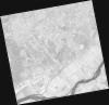
DE2_OPER_HRA_PSH_1C_20210721T111652_N39-102_W008-848_0001
Download Product | Product Info | Browse
Platform Short Name | GEOSAT |
Platform Serial Identifier | 2 |
Product Type | HRA_PSH_1C |
Start Date | 2021-07-21T11:16:52Z |
Stop Date | 2021-07-21T11:16:55Z |
Original Name | DE2_PSH_L1C_000000_20210721T111652_20210721T111655_DE2_38410_6159.zip |
Footprint | 39.0452470587 -8.73949762188 39.1843914228 -8.77327751587 39.1590644014 -8.95706185652 39.0199383534 -8.92282896279 39.0452470587 -8.73949762188 |
Orbit Direction | ASCENDING |
Scene Centre Longitude | W008 |
Scene Centre Latitude | N39 |
Cloud Cover Percentage | -1 |
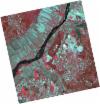
DE2_OPER_HRA_PM4_1C_20210721T111652_N39-102_W008-848_0001
Download Product | Product Info | Browse
Platform Short Name | GEOSAT |
Platform Serial Identifier | 2 |
Product Type | HRA_PM4_1C |
Start Date | 2021-07-21T11:16:52Z |
Stop Date | 2021-07-21T11:16:55Z |
Original Name | DE2_PM4_L1C_000000_20210721T111652_20210721T111655_DE2_38410_6159.zip |
Footprint | 39.0452470587 -8.73949762188 39.1843914228 -8.77327751587 39.1590644014 -8.95706185652 39.0199383534 -8.92282896279 39.0452470587 -8.73949762188 |
Orbit Direction | ASCENDING |
Scene Centre Longitude | W008 |
Scene Centre Latitude | N39 |
Cloud Cover Percentage | -1 |
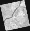
DE2_OPER_HRA_PSH_1C_20210721T111650_N38-975_W008-817_0001
Download Product | Product Info | Browse
Platform Short Name | GEOSAT |
Platform Serial Identifier | 2 |
Product Type | HRA_PSH_1C |
Start Date | 2021-07-21T11:16:50Z |
Stop Date | 2021-07-21T11:16:53Z |
Original Name | DE2_PSH_L1C_000000_20210721T111650_20210721T111653_DE2_38410_45D2.zip |
Footprint | 38.9189335805 -8.70941182797 39.0581220929 -8.74263162568 39.0328220628 -8.9259691355 38.8936506319 -8.89228994081 38.9189335805 -8.70941182797 |
Orbit Direction | ASCENDING |
Scene Centre Longitude | W008 |
Scene Centre Latitude | N38 |
Cloud Cover Percentage | -1 |
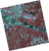
DE2_OPER_HRA_PM4_1C_20210721T111650_N38-975_W008-817_0001
Download Product | Product Info | Browse
Platform Short Name | GEOSAT |
Platform Serial Identifier | 2 |
Product Type | HRA_PM4_1C |
Start Date | 2021-07-21T11:16:50Z |
Stop Date | 2021-07-21T11:16:53Z |
Original Name | DE2_PM4_L1C_000000_20210721T111650_20210721T111653_DE2_38410_45D2.zip |
Footprint | 38.9189335805 -8.70941182797 39.0581220929 -8.74263162568 39.0328220628 -8.9259691355 38.8936506319 -8.89228994081 38.9189335805 -8.70941182797 |
Orbit Direction | ASCENDING |
Scene Centre Longitude | W008 |
Scene Centre Latitude | N38 |
Cloud Cover Percentage | -1 |
DE2_OPER_HRA_PSH_1C_20210507T111127_N39-070_W008-744_0001
Download Product | Product Info | Browse
Platform Short Name | GEOSAT |
Platform Serial Identifier | 2 |
Product Type | HRA_PSH_1C |
Start Date | 2021-05-07T11:11:27Z |
Stop Date | 2021-05-07T11:11:30Z |
Original Name | DE2_PSH_L1C_000000_20210507T111127_20210507T111130_DE2_37297_7821.zip |
Footprint | 39.019761082 -8.65153314366 39.1464769399 -8.68576495127 39.1220920574 -8.83737794624 38.9954324591 -8.80259212625 39.019761082 -8.65153314366 |
Orbit Direction | ASCENDING |
Scene Centre Longitude | W008 |
Scene Centre Latitude | N39 |
Cloud Cover Percentage | -1 |
DE2_OPER_HRA_PM4_1C_20210507T111127_N39-070_W008-744_0001
Download Product | Product Info | Browse
Platform Short Name | GEOSAT |
Platform Serial Identifier | 2 |
Product Type | HRA_PM4_1C |
Start Date | 2021-05-07T11:11:27Z |
Stop Date | 2021-05-07T11:11:30Z |
Original Name | DE2_PM4_L1C_000000_20210507T111127_20210507T111130_DE2_37297_7821.zip |
Footprint | 39.019761082 -8.65153314366 39.1464769399 -8.68576495127 39.1220920574 -8.83737794624 38.9954324591 -8.80259212625 39.019761082 -8.65153314366 |
Orbit Direction | ASCENDING |
Scene Centre Longitude | W008 |
Scene Centre Latitude | N39 |
Cloud Cover Percentage | -1 |
DE2_OPER_HRA_PSH_1C_20210507T111125_N38-955_W008-713_0001
Download Product | Product Info | Browse
Platform Short Name | GEOSAT |
Platform Serial Identifier | 2 |
Product Type | HRA_PSH_1C |
Start Date | 2021-05-07T11:11:25Z |
Stop Date | 2021-05-07T11:11:28Z |
Original Name | DE2_PSH_L1C_000000_20210507T111125_20210507T111128_DE2_37297_D96D.zip |
Footprint | 38.9046086319 -8.62099246214 39.0315099959 -8.65471622015 39.0071773697 -8.80579914777 38.8802979119 -8.77176542234 38.9046086319 -8.62099246214 |
Orbit Direction | ASCENDING |
Scene Centre Longitude | W008 |
Scene Centre Latitude | N38 |
Cloud Cover Percentage | -1 |
DE2_OPER_HRA_PM4_1C_20210507T111125_N38-955_W008-713_0001
Download Product | Product Info | Browse
Platform Short Name | GEOSAT |
Platform Serial Identifier | 2 |
Product Type | HRA_PM4_1C |
Start Date | 2021-05-07T11:11:25Z |
Stop Date | 2021-05-07T11:11:28Z |
Original Name | DE2_PM4_L1C_000000_20210507T111125_20210507T111128_DE2_37297_D96D.zip |
Footprint | 38.9046086319 -8.62099246214 39.0315099959 -8.65471622015 39.0071773697 -8.80579914777 38.8802979119 -8.77176542234 38.9046086319 -8.62099246214 |
Orbit Direction | ASCENDING |
Scene Centre Longitude | W008 |
Scene Centre Latitude | N38 |
Cloud Cover Percentage | -1 |