ESA TPM Map Catalogue - Product List
back to previous node |
list of download URLs


Collection G2_Portugal_2021
GEOSAT-2 Portugal Coverage 2021 collection. More details here.
List of available products (latitude from 38.7299 to 38.8083 dg, longitude from -8.39938 to -8.255 dg)..
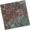
DE2_OPER_HRA_PSH_1C_20210921T111133_N38-877_W008-209_0001
Download Product | Product Info | Browse
Platform Short Name | GEOSAT |
Platform Serial Identifier | 2 |
Product Type | HRA_PSH_1C |
Start Date | 2021-09-21T11:11:33Z |
Stop Date | 2021-09-21T11:11:36Z |
Original Name | DE2_PSH_L1C_000000_20210921T111133_20210921T111136_DE2_39330_1866.zip |
Footprint | 38.8213085948 -8.10352102023 38.9593802439 -8.13616601042 38.9342839537 -8.31512380765 38.7962566031 -8.28184045552 38.8213085948 -8.10352102023 |
Orbit Direction | ASCENDING |
Scene Centre Longitude | W008 |
Scene Centre Latitude | N38 |
Cloud Cover Percentage | -1 |
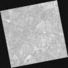
DE2_OPER_HRA_PM4_1C_20210921T111133_N38-877_W008-209_0001
Download Product | Product Info | Browse
Platform Short Name | GEOSAT |
Platform Serial Identifier | 2 |
Product Type | HRA_PM4_1C |
Start Date | 2021-09-21T11:11:33Z |
Stop Date | 2021-09-21T11:11:36Z |
Original Name | DE2_PM4_L1C_000000_20210921T111133_20210921T111136_DE2_39330_1866.zip |
Footprint | 38.8213085948 -8.10352102023 38.9593802439 -8.13616601042 38.9342839537 -8.31512380765 38.7962566031 -8.28184045552 38.8213085948 -8.10352102023 |
Orbit Direction | ASCENDING |
Scene Centre Longitude | W008 |
Scene Centre Latitude | N38 |
Cloud Cover Percentage | -1 |
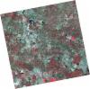
DE2_OPER_HRA_PSH_1C_20210921T111131_N38-752_W008-178_0001
Download Product | Product Info | Browse
Platform Short Name | GEOSAT |
Platform Serial Identifier | 2 |
Product Type | HRA_PSH_1C |
Start Date | 2021-09-21T11:11:31Z |
Stop Date | 2021-09-21T11:11:34Z |
Original Name | DE2_PSH_L1C_000000_20210921T111131_20210921T111134_DE2_39330_345E.zip |
Footprint | 38.6959055902 -8.07357541766 38.8340846308 -8.10648015165 38.8090220414 -8.28488245303 38.6709313336 -8.25083306747 38.6959055902 -8.07357541766 |
Orbit Direction | ASCENDING |
Scene Centre Longitude | W008 |
Scene Centre Latitude | N38 |
Cloud Cover Percentage | -1 |
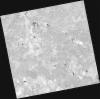
DE2_OPER_HRA_PM4_1C_20210921T111131_N38-752_W008-178_0001
Download Product | Product Info | Browse
Platform Short Name | GEOSAT |
Platform Serial Identifier | 2 |
Product Type | HRA_PM4_1C |
Start Date | 2021-09-21T11:11:31Z |
Stop Date | 2021-09-21T11:11:34Z |
Original Name | DE2_PM4_L1C_000000_20210921T111131_20210921T111134_DE2_39330_345E.zip |
Footprint | 38.6959055902 -8.07357541766 38.8340846308 -8.10648015165 38.8090220414 -8.28488245303 38.6709313336 -8.25083306747 38.6959055902 -8.07357541766 |
Orbit Direction | ASCENDING |
Scene Centre Longitude | W008 |
Scene Centre Latitude | N38 |
Cloud Cover Percentage | -1 |
DE2_OPER_HRA_PSH_1C_20210827T111048_N38-844_W008-467_0001
Download Product | Product Info | Browse
Platform Short Name | GEOSAT |
Platform Serial Identifier | 2 |
Product Type | HRA_PSH_1C |
Start Date | 2021-08-27T11:10:48Z |
Stop Date | 2021-08-27T11:10:51Z |
Original Name | DE2_PSH_L1C_000000_20210827T111048_20210827T111051_DE2_38959_5405.zip |
Footprint | 38.7903876608 -8.36798943702 38.9233497678 -8.40137581427 38.8987549432 -8.5663966619 38.76586394 -8.53255835522 38.7903876608 -8.36798943702 |
Orbit Direction | ASCENDING |
Scene Centre Longitude | W008 |
Scene Centre Latitude | N38 |
Cloud Cover Percentage | -1 |
DE2_OPER_HRA_PM4_1C_20210827T111048_N38-844_W008-467_0001
Download Product | Product Info | Browse
Platform Short Name | GEOSAT |
Platform Serial Identifier | 2 |
Product Type | HRA_PM4_1C |
Start Date | 2021-08-27T11:10:48Z |
Stop Date | 2021-08-27T11:10:51Z |
Original Name | DE2_PM4_L1C_000000_20210827T111048_20210827T111051_DE2_38959_5405.zip |
Footprint | 38.7903876608 -8.36798943702 38.9233497678 -8.40137581427 38.8987549432 -8.5663966619 38.76586394 -8.53255835522 38.7903876608 -8.36798943702 |
Orbit Direction | ASCENDING |
Scene Centre Longitude | W008 |
Scene Centre Latitude | N38 |
Cloud Cover Percentage | -1 |
DE2_OPER_HRA_PSH_1C_20210827T111046_N38-724_W008-436_0001
Download Product | Product Info | Browse
Platform Short Name | GEOSAT |
Platform Serial Identifier | 2 |
Product Type | HRA_PSH_1C |
Start Date | 2021-08-27T11:10:46Z |
Stop Date | 2021-08-27T11:10:49Z |
Original Name | DE2_PSH_L1C_000000_20210827T111046_20210827T111049_DE2_38959_660C.zip |
Footprint | 38.6699819378 -8.3376765126 38.8027252232 -8.37105034624 38.778190287 -8.53555174019 38.6454445344 -8.50199654525 38.6699819378 -8.3376765126 |
Orbit Direction | ASCENDING |
Scene Centre Longitude | W008 |
Scene Centre Latitude | N38 |
Cloud Cover Percentage | -1 |
DE2_OPER_HRA_PM4_1C_20210827T111046_N38-724_W008-436_0001
Download Product | Product Info | Browse
Platform Short Name | GEOSAT |
Platform Serial Identifier | 2 |
Product Type | HRA_PM4_1C |
Start Date | 2021-08-27T11:10:46Z |
Stop Date | 2021-08-27T11:10:49Z |
Original Name | DE2_PM4_L1C_000000_20210827T111046_20210827T111049_DE2_38959_660C.zip |
Footprint | 38.6699819378 -8.3376765126 38.8027252232 -8.37105034624 38.778190287 -8.53555174019 38.6454445344 -8.50199654525 38.6699819378 -8.3376765126 |
Orbit Direction | ASCENDING |
Scene Centre Longitude | W008 |
Scene Centre Latitude | N38 |
Cloud Cover Percentage | -1 |
DE2_OPER_HRA_PSH_1C_20210331T111523_N38-841_W008-340_0001
Download Product | Product Info | Browse
Platform Short Name | GEOSAT |
Platform Serial Identifier | 2 |
Product Type | HRA_PSH_1C |
Start Date | 2021-03-31T11:15:23Z |
Stop Date | 2021-03-31T11:15:26Z |
Original Name | DE2_PSH_L1C_000000_20210331T111523_20210331T111526_DE2_36748_56BB.zip |
Footprint | 38.7869933332 -8.24059600401 38.9201457686 -8.27384512396 38.8954352712 -8.44055453103 38.7623182084 -8.40654779118 38.7869933332 -8.24059600401 |
Orbit Direction | ASCENDING |
Scene Centre Longitude | W008 |
Scene Centre Latitude | N38 |
Cloud Cover Percentage | -1 |
DE2_OPER_HRA_PM4_1C_20210331T111523_N38-841_W008-340_0001
Download Product | Product Info | Browse
Platform Short Name | GEOSAT |
Platform Serial Identifier | 2 |
Product Type | HRA_PM4_1C |
Start Date | 2021-03-31T11:15:23Z |
Stop Date | 2021-03-31T11:15:26Z |
Original Name | DE2_PM4_L1C_000000_20210331T111523_20210331T111526_DE2_36748_56BB.zip |
Footprint | 38.7869933332 -8.24059600401 38.9201457686 -8.27384512396 38.8954352712 -8.44055453103 38.7623182084 -8.40654779118 38.7869933332 -8.24059600401 |
Orbit Direction | ASCENDING |
Scene Centre Longitude | W008 |
Scene Centre Latitude | N38 |
Cloud Cover Percentage | -1 |
DE2_OPER_HRA_PM4_1C_20210331T111521_N38-720_W008-310_0001
Download Product | Product Info | Browse
Platform Short Name | GEOSAT |
Platform Serial Identifier | 2 |
Product Type | HRA_PM4_1C |
Start Date | 2021-03-31T11:15:21Z |
Stop Date | 2021-03-31T11:15:24Z |
Original Name | DE2_PM4_L1C_000000_20210331T111521_20210331T111524_DE2_36748_7F8C.zip |
Footprint | 38.6660765085 -8.21045217228 38.7993149235 -8.24381633412 38.7746559533 -8.40983006063 38.6414210124 -8.3761253184 38.6660765085 -8.21045217228 |
Orbit Direction | ASCENDING |
Scene Centre Longitude | W008 |
Scene Centre Latitude | N38 |
Cloud Cover Percentage | -1 |
DE2_OPER_HRA_PSH_1C_20210331T111521_N38-720_W008-310_0001
Download Product | Product Info | Browse
Platform Short Name | GEOSAT |
Platform Serial Identifier | 2 |
Product Type | HRA_PSH_1C |
Start Date | 2021-03-31T11:15:21Z |
Stop Date | 2021-03-31T11:15:24Z |
Original Name | DE2_PSH_L1C_000000_20210331T111521_20210331T111524_DE2_36748_7F8C.zip |
Footprint | 38.6660765085 -8.21045217228 38.7993149235 -8.24381633412 38.7746559533 -8.40983006063 38.6414210124 -8.3761253184 38.6660765085 -8.21045217228 |
Orbit Direction | ASCENDING |
Scene Centre Longitude | W008 |
Scene Centre Latitude | N38 |
Cloud Cover Percentage | -1 |