ESA TPM Map Catalogue - Product List
back to previous node |
list of download URLs

Collection G2_Portugal_2021
GEOSAT-2 Portugal Coverage 2021 collection. More details here.
List of available products (latitude from 38.459 to 38.5374 dg, longitude from -7.75625 to -7.61188 dg)..
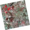
DE2_OPER_HRA_PSH_1C_20210702T111142_N38-488_W007-574_0001
Download Product | Product Info | Browse
Platform Short Name | GEOSAT |
Platform Serial Identifier | 2 |
Product Type | HRA_PSH_1C |
Start Date | 2021-07-02T11:11:42Z |
Stop Date | 2021-07-02T11:11:45Z |
Original Name | DE2_PSH_L1C_000000_20210702T111142_20210702T111145_DE2_38128_AA14.zip |
Footprint | 38.4325782563 -7.4697927672 38.5698847704 -7.50375563842 38.5449004403 -7.67915376984 38.4075160966 -7.64541041608 38.4325782563 -7.4697927672 |
Orbit Direction | ASCENDING |
Scene Centre Longitude | W007 |
Scene Centre Latitude | N38 |
Cloud Cover Percentage | -1 |
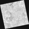
DE2_OPER_HRA_PM4_1C_20210702T111142_N38-488_W007-574_0001
Download Product | Product Info | Browse
Platform Short Name | GEOSAT |
Platform Serial Identifier | 2 |
Product Type | HRA_PM4_1C |
Start Date | 2021-07-02T11:11:42Z |
Stop Date | 2021-07-02T11:11:45Z |
Original Name | DE2_PM4_L1C_000000_20210702T111142_20210702T111145_DE2_38128_AA14.zip |
Footprint | 38.4325782563 -7.4697927672 38.5698847704 -7.50375563842 38.5449004403 -7.67915376984 38.4075160966 -7.64541041608 38.4325782563 -7.4697927672 |
Orbit Direction | ASCENDING |
Scene Centre Longitude | W007 |
Scene Centre Latitude | N38 |
Cloud Cover Percentage | -1 |
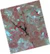
DE2_OPER_HRA_PSH_1C_20210525T110116_N38-535_W007-722_0001
Download Product | Product Info | Browse
Platform Short Name | GEOSAT |
Platform Serial Identifier | 2 |
Product Type | HRA_PSH_1C |
Start Date | 2021-05-25T11:01:16Z |
Stop Date | 2021-05-25T11:01:19Z |
Original Name | DE2_PSH_L1C_000000_20210525T110116_20210525T110119_DE2_37564_7221.zip |
Footprint | 38.486846499 -7.63463087817 38.6098290701 -7.67009107248 38.5848841727 -7.81084671486 38.4618996356 -7.77518340293 38.486846499 -7.63463087817 |
Orbit Direction | ASCENDING |
Scene Centre Longitude | W007 |
Scene Centre Latitude | N38 |
Cloud Cover Percentage | -1 |
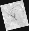
DE2_OPER_HRA_PM4_1C_20210525T110116_N38-535_W007-722_0001
Download Product | Product Info | Browse
Platform Short Name | GEOSAT |
Platform Serial Identifier | 2 |
Product Type | HRA_PM4_1C |
Start Date | 2021-05-25T11:01:16Z |
Stop Date | 2021-05-25T11:01:19Z |
Original Name | DE2_PM4_L1C_000000_20210525T110116_20210525T110119_DE2_37564_7221.zip |
Footprint | 38.486846499 -7.63463087817 38.6098290701 -7.67009107248 38.5848841727 -7.81084671486 38.4618996356 -7.77518340293 38.486846499 -7.63463087817 |
Orbit Direction | ASCENDING |
Scene Centre Longitude | W007 |
Scene Centre Latitude | N38 |
Cloud Cover Percentage | -1 |
DE2_OPER_HRA_PSH_1C_20210525T110114_N38-424_W007-690_0001
Download Product | Product Info | Browse
Platform Short Name | GEOSAT |
Platform Serial Identifier | 2 |
Product Type | HRA_PSH_1C |
Start Date | 2021-05-25T11:01:14Z |
Stop Date | 2021-05-25T11:01:17Z |
Original Name | DE2_PSH_L1C_000000_20210525T110114_20210525T110117_DE2_37564_B57B.zip |
Footprint | 38.3753204894 -7.60250690699 38.4982327658 -7.63793348247 38.4732959456 -7.77851557303 38.3504011968 -7.74283527564 38.3753204894 -7.60250690699 |
Orbit Direction | ASCENDING |
Scene Centre Longitude | W007 |
Scene Centre Latitude | N38 |
Cloud Cover Percentage | -1 |
DE2_OPER_HRA_PM4_1C_20210525T110114_N38-424_W007-690_0001
Download Product | Product Info | Browse
Platform Short Name | GEOSAT |
Platform Serial Identifier | 2 |
Product Type | HRA_PM4_1C |
Start Date | 2021-05-25T11:01:14Z |
Stop Date | 2021-05-25T11:01:17Z |
Original Name | DE2_PM4_L1C_000000_20210525T110114_20210525T110117_DE2_37564_B57B.zip |
Footprint | 38.3753204894 -7.60250690699 38.4982327658 -7.63793348247 38.4732959456 -7.77851557303 38.3504011968 -7.74283527564 38.3753204894 -7.60250690699 |
Orbit Direction | ASCENDING |
Scene Centre Longitude | W007 |
Scene Centre Latitude | N38 |
Cloud Cover Percentage | -1 |